Call us : +212 662 432890

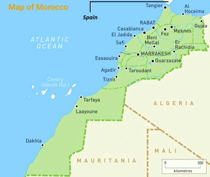
Map of Morocco
The map of Morocco reveals a country rich in both geography and culture. Located in Northwest Africa, Morocco spans around 710,850 square kilometers, bordered by the Atlantic Ocean, Mediterranean Sea, and neighboring Algeria. From the Atlas Mountains to the Sahara Desert, the Moroccan map showcases an extraordinary variety of landscapes.
This guide explores Morocco layout in depth its major cities, 12 regions, road systems, and natural features. Whether you’re studying a printable map of Morocco, planning a trip, or exploring its cultural and historical regions, this guide offers valuable insight into the country’s unique geography and its place on the African continent.
Where is Morocco on the Map?
Located at the crossroads of Africa and Europe, Morocco commands a strategic position in the continent’s northwest. To its east and southeast lies Algeria, while the Strait of Gibraltar to the north places it just across from Spain. With its dual coastlines along the Atlantic Ocean and the Mediterranean Sea, Morocco enjoys a unique maritime advantage that has shaped its cultural and economic ties for centuries.
Key facts:
- Part of the Arab world and the Islamic cultural sphere.
- Acts as a bridge between Europe and Africa.
- Coordinates: Approximately 32° N latitude and 6° W longitude.
- Administrative Divisions and Political Boundaries
A political map of the country shows 12 administrative regions, each further divided into provinces and prefectures. These regions include:
- Casablanca-Settat
- Rabat-Salé-Kénitra
- Marrakech-Safi
- Fès-Meknès
- Tanger-Tétouan-Al Hoceïma
- Souss-Massa
- Drâa-Tafilalet
- Béni Mellal-Khénifra
- Guelmim-Oued Noun
- Laâyoune-Sakia El Hamra (partly disputed)
- Dakhla-Oued Ed-Dahab (partly disputed)
Each area reflects a distinct identity influenced by local dialects, topography, and cultural traditions.
Map of Morocco with Cities
A Morocco map with cities highlights the country’s major urban centers. Here are the largest cities in Morocco, along with estimated populations:
- Casablanca: 3.7 million
- Rabat (Capital): 1.7 million
- Fes: 1.2 million
- Marrakech: 1.1 million
- Tangier: 1.0 million
- Agadir: 950,000
- Meknès: 850,000
City-specific guides are popular for tourism and research:
- Marrakech overview: Famous for its souks and Medina
- Casablanca city layout: Economic powerhouse
- Fes heritage map: Medieval charm
- Tangier coast: Gateway to the Mediterranean
Regional and Provincial Breakdown
Looking beyond city limits, provincial maps offer a clearer view of internal divisions. These maps are essential for understanding local governance, ethnic groups, and infrastructure.
Geography and Natural Landscape
Morocco Topography Map
A terrain map showcases Morocco varied physical features:
- Atlas Mountains: Divide the country and offer hiking and skiing.
- Rif Mountains: Lush, forested northern region
- Sahara Desert: Arid southeast with dramatic dunes
- Coastal Plains: Fertile and densely populated
- Interior Plateaus: Semi-arid with deep Amazigh roots
Natural Features and Ecosystems
Important natural landmarks include:
- Rivers: Oum Er-Rbia, Sebou, Draa
- Lakes: Bin el Ouidane, Dayet Aoua
- National Parks: Toubkal, Souss-Massa, Ifrane
Transport and Road Network
A national highway map helps travelers navigate Morocco extensive road system. Key routes:
- A1: Tangier to Casablanca
- A3: Casablanca to Fès
- N1: Atlantic route to Dakhla
Offline maps are helpful for tourists exploring rural or lesser-known destinations.
Digital and Printable Navigation Tools
Interactive maps from platforms like Google Maps or Mapbox offer real-time assistance for:
- Tourist attractions
- Accommodation
- Restaurants and landmarks
Offline, printable versions can include:
- Regional borders
- Highways
- UNESCO World Heritage Sites
Historical Evolution of Borders
Historical maps provide insight into how Morocco current boundaries came to be. Over the centuries, the land has been shaped by:
- Indigenous Berber kingdoms.
- Islamic empires: Almoravid, Almohad, Merinid.
- French and Spanish colonial rule.
- The evolving Western Sahara conflict.
These visual tools are of great value to historians and students alike.
Cultural and Ethnic Diversity
Morocco is a cultural mosaic:
- Arab populations dominate cities and administration.
- Berber (Amazigh) communities thrive in mountainous and rural areas.
- Sub-Saharan African influence is strong in southern regions.
- Jewish and Andalusian heritage is visible in cities like Fès and Essaouira.
A cultural distribution map would reveal:
- Linguistic diversity: Arabic, Tamazight, French, Spanish.
- Religious landscape: Predominantly Muslim with minority faiths.
- Festivals: Eid al-Fitr, Gnaoua Festival, Imilchil Marriage Festival
Regional Context and Comparative Maps
To better understand Morocco position:
- Arab World map: Cultural and linguistic connections
- Arab world: Linguistic and cultural connections
- Neighboring countries: Algeria, Tunisia, Western Sahara
Conclusion of Moroccan Map
Whether you’re a traveler, student, or curious explorer, a Map of Morocco offers valuable insights into this diverse and beautiful country. From political and physical maps to interactive tools and historical maps, you now have a complete resource to navigate and appreciate everything Morocco has to offer.
Start your journey today by exploring a detailed map and uncover its hidden gems, one region at a time.
